Wednesday, 26 May 2021

Bird ringing and nest box checks on the Windrush Path

In February 2020, the Lower Windrush Valley Project put up 12 small bird nest boxes along the Windrush Path near Standlake, 6 open fronted boxes and 6 with a 32mm hole. The boxes were purchased using funds raised through a nest box adoption scheme and supported by Linear Fisheries. A further 5 wooden nest boxes were already present along the path.

In May 2021, we invited our nest box sponsors to join us making nest box checks and ringing any birds using the boxes. We were thrilled with the success of the new boxes - 97 chicks and 3 adults ringed as part of the British Trust for Ornithology ringing scheme.

Great tit chick

Bird ringing generates information on the survival, productivity and movements of birds, helping us to understand why populations are changing. This data makes a major contribution to the study of population changes and to our understanding of species declines.

We made a short video with photos and footage of our visits including a demonstration of fitting a ring. It can be viewed on YouTube here: https://youtu.be/DxvIQhp2SAc

Thursday, 22 April 2021

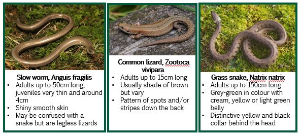
Lower Windrush Valley Reptile Survey Group launches

We have recently received a grant from the Nineveh Charitable Trust to expand volunteer recording across the Lower Windrush and have now launched the Lower Windrush Valley Reptile Survey Group. Initially, ten volunteers have been recruited to survey four sites across the valley between April and October. These include Rushy Common nature reserve and three allotment sites.


Allotments have a diversity of habitats which is ideal for reptiles. Bare earth and debris provide plenty of basking spots; long grass provides areas to forage; and compost heaps provide somewhere to hibernate and lay eggs. Reptiles are generally active between March to October. Areas that will be particularly attractive to reptiles are:

      Embankments and mounds

      Logs, brash piles

      Stoney areas with crevices eg. dry stone walls

      Paths or clearings in denser vegetation

      Edge of bramble patches and grassy areas

      Compost heaps, grass cuttings

An online training session with Oxfordshire Amphibian Reptile Group (OxARG) took place on at the beginning of April and during the last week we have been laying down reptile refugia and familiarising the volunteers with their sites.  


We’ll use the records collected this year to help us select sites for future years and identify locations for habitat creation.

Juvenile Common lizard

Friday, 5 February 2021

Biodiversity opportunities in the Lower Windrush Valley

The Lower Windrush Valley supports a wealth of biodiversity and is identified in the draft Oxfordshire Nature Recovery Network as a priority area for habitat creation and restoration or ‘recovery zone’. A substantial area of the valley is also identified as requiring the highest level of biodiversity protection, management and enhancement or ‘core zone’.

The LWVP have recently published a review of biodiversity opportunities in the Lower Windrush Valley which used aerial photography and data held by the Thames Valley Environmental Records Centre to produce valley-wide habitat maps. These maps, along with species data and specialist knowledge of the area, were used to set out objectives for key habitats and identify opportunity areas where activities to create, connect, extend or enhance habitats would be most beneficial. 

Phase 1 Habitat Map of the Lower Windrush Valley

The review will be used to direct the biodiversity and nature conservation elements of the LWVP strategy but a collaborative approach between landowners, minerals operators, local authorities and other organisations will be required in order to meet the objectives set out. 

Click the link below to view the full document on our website.

Review of biodiversity opportunities in the Lower Windrush Valley


Monday, 2 November 2020

Nest box adoption scheme: Year 1 update

In February 2020, the Lower Windrush Valley Project put up 12 small bird nest boxes along the Windrush Path near Standlake, 6 open fronted boxes and 6 with a 32mm hole. The boxes were purchased using funds raised through a nest box adoption scheme and supported by Linear Fisheries.

Box locations

The sections of footpath selected for the boxes have excellent surrounding foraging habitat for small passerine birds, with hedgerows containing berries running alongside much of the path and insects attracted by the lakes and streams. As the planting around the gravel pit lakes and surrounding footpaths is relatively recent, the trees are generally young and thin, with few holes present for cavity nesting birds present due to their small size and good health. These boxes therefore make a great artificial alternative for such cavities, and will allow passerine populations to breed and grow in the area.


Nest box use in Year 1

Unfortunately, due to the Coronavirus pandemic we were unable to run the ringing sessions we had planned in May. Information on breeding attempts in 2020 is therefore based on what was found when the boxes were emptied after the breeding season to remove old nesting material, which can contain parasites that could remain and infect any young birds in the boxes next year.

The boxes have proved hugely successful, with 8 of the 12 boxes showing evidence of use and successful breeding confirmed in 5 boxes. Looking at unhatched eggs within the boxes, it can be assumed that they were used by blue tits and/or great tits. We were surprised to find an occupant in one of the open-fronted boxes – a pipistrelle bat was using it as a safe place to roost!

Our little owl boxes have been installed, in suitable locations along the Windrush Path, and we are excited to see their use next season.

Box type

Number

Date checked

Result

Open fronted

1

22/10/2020

No evidence of use

Open fronted

2

22/10/2020

No evidence of use

Open fronted

3

22/10/2020

Small attempt at nest building made

Open fronted

4

22/10/2020

No evidence of use

Open fronted

5

22/10/2020

No evidence of use

Open fronted

6

22/10/2020

Successful breeding – 2 unhatched eggs*

32mm hole

1

22/10/2020

Successful breeding – chick remains, believed to be great tit*

32mm hole

2

22/10/2020

Successful breeding – chick remains*

32mm hole

3

22/10/2020

Successful breeding – 1 unhatched egg*

32mm hole

4

22/10/2020

Evidence of use – full nest

32mm hole

5

22/10/2020

Evidence of use. Bat using box so not emptied

32mm hole

6

22/10/2020

Successful breeding – egg fragments

 * It is quite normal for some young to die or eggs to fail to hatch. A large number of eggs are laid by parents to account for losses. 


Friday, 9 October 2020

Kingfisher Quest Project Completed

Earlier this year, we asked Lower Windrush Valley residents and visitors to send us details of Kingfisher sightings in the valley for Kingfisher Quest. 

We'd like to say a big thank you to everybody who engaged with the project, a summary of the results can be found below. 

To mark the end of the project we held an online event, ‘A season with Kingfishers’, with wildlife photographer and Kingfisher enthusiast Steve Midgley. 

The event was recorded and is now available to watch online here: https://us02web.zoom.us/rec/share/WWnS_Q0evtgRNqfVp5yD5KNa4OuiksqTIQX5BPBNH4igVcAw27tgCP9dHkcrW2Wr.igVowVLOMStW7Z1U?startTime=1602007310000


Monday, 14 September 2020

Walking in the Lower Windrush Valley – Spotlight on the Northmoor Thames circular

Here is the final instalment in our series of blogs putting a spotlight on the three routes promoted as part of our circular walk project.

Northmoor Thames Circular Walk

Distance: 6 kilometres

Time: Approximately 1 hour 15 minutes

Start and end point: The Red Lion community pub in Northmoor, OX29 5SX

The route begins at the Red Lion pub and after a short walk along the road you head south towards the River Thames through farmland.

Much of the area is used for grazing sheep and cattle so you are likely to come across both on this walk. Please keep dogs on a lead and under control in fields with livestock. 

Ramblers advice for walking near livestock: https://www.ramblers.org.uk/advice/safety/walking-near-livestock.aspx


As you near the River Thames you will see Hart’s Weir footbridge where you will turn left to follow the river.

Hart's Weir footbridge

View of the Thames from Hart's Weir footbridge

The route follows the Thames Path National Trail through riverside meadows before reaching Northmoor Lock.

Northmoor Lock

After passing the lock, you start to make you way back towards the village where you can stop in at the Red Lion for a drink or lunch.

If you would like to try the route out, a map and directions can be downloaded here: http://www.oxfordshire.gov.uk/sites/default/files/file/countryside-walks-rides/NorthmoorThamesPathCircularRoute.pdf

Thank you to the landowners for their support and our funders for the project - Trust for Oxfordshire’s Environment (TOE) with funding from Grundon Waste Management Ltd through the Landfill Communities Fund and the Thames Path National Trail.


Tuesday, 11 August 2020

Walking in the Lower Windrush Valley - Spotlight on the Northmoor short circular

Here is the next instalment in our series of blogs putting a spotlight on three circular walks promoted as part of a project earlier this year. Today it's the turn of the Northmoor short circular. 

Distance: 2.5 kilometres, stile free
Time: Approximately 35 minutes
Start and end point: The Red Lion community pub in Northmoor, OX29 5SX


This walk is ideal if you’re looking for a short stroll after a visit to the Red Lion or for those less able to enjoy longer country walks.

The route includes footpaths through farmland where you can enjoy field boundaries bursting with butterflies and other insects and quiet village roads where you can admire the pretty cottages.
One of the footpaths along a field boundary
Part of our funding allowed us to make this particular route more accessible by replacing three stiles with gates. The route is now stile free.
One of the newly installed gates

If you would like to try the route out, a map and directions can be downloaded here: https://www.oxfordshire.gov.uk/sites/default/files/file/countryside-walks-rides/NorthmoorShortCircularRoute.pdf

Thank you to the landowners for their support and our funders for the project - Trust for Oxfordshire’s Environment (TOE) with funding from Grundon Waste Management Ltd through the Landfill Communities Fund.
The Red Lion Pub


Thursday, 9 July 2020

Walking in the Lower Windrush Valley - Spotlight on the Gill Mill Circular


We recently completed a project to improve and promote three circular walks in the Lower Windrush Valley. Today we’re putting a spotlight on one of those routes, the Gill Mill Circular Walk.


New waymarking discs signposting the route
Distance: 8 kilometres, stile free
Time: Allow at least 1 hour 45 minutes
Start and end point: Rushy Common Car Park, Grid reference SP 380 074, Postcode OX29 6UJ
The route begins at Rushy Common Nature Reserve Car Park where you start by walking towards Ducklington along two permissive bridleways.

Down Valley Way bridleway
The bridleways were opened 2015 by Smiths Bletchington as part of the Gill Mill quarry development. They link in with existing Rights of Way, as well as the Windrush Path, creating a circular route that connects Ducklington, Rushy Common Nature Reserve and Hardwick.
 
A lot of the area is currently farmed but over time the scenery from the will evolve to quarry workings, and eventually a 60 hectare reedbed and lakes created for nature conservation and recreation.
 
Before reaching Ducklington you’ll cross the western arm of the River Windrush. Keep your eyes out for Water Voles in this area as they’re often sighted from the bridge.

Water Vole on the River Windrush. Photo credit: Justin Hoffmann

View from the bridge crossing the Windrush
Once nearing Ducklington you will join the Windrush Path and follow the banks of the River Windrush south before crossing West back towards Tar Lakes and the walk’s conclusion.


The Windrush Path


Tar Lakes


Tar Lakes

 
Thank you to Smiths Bletchington for their support and maintenance of the permissive footpaths and bridleways and our funders for the project - Trust for Oxfordshire’s Environment (TOE) with funding from Grundon Waste Management Ltd through the Landfill Communities Fund.


Scarlett Tiger Moth on Windrush Path


Tuesday, 23 June 2020

Improving access and promoting circular walks in the Lower Windrush Valley


Last year, the Lower Windrush Valley Project secured funding to improve access and promote three beautiful circular walks in the Lower Windrush Valley. We have:

New kissing gate to replace stile

New route signage
The three routes have been selected because of their ease of access, beautiful scenery, proximity to local businesses and nature reserves, and links with the Windrush Path and Thames Path National Trail. There is something for everyone – the walks vary in length from 2.5km to 8km and two of the routes are now stile free.

The project was funded by Trust for Oxfordshire’s Environment (TOE) with funding from Grundon Waste Management Ltd through the Landfill Communities Fund, and additional support provided by Thames Path National Trail and the Oxfordshire County Council Rights of Way improvement budget.

We hope that the three routes will provide easy to navigate route for visitors and locals. If you’re walking in and around the Lower Windrush Valley, please remember to follow government guidelines regarding social distancing.


Tar Lakes - part of the Gill Mill circular route

Friday, 29 May 2020

Kingfisher Quest


We’re delighted to announce the launch of Kingfisher Quest, a Kingfisher survey across the Lower Windrush Valley from 1st June to 31st August. 

A copy of the survey leaflet below tells you more about the survey and how to submit your sightings. We also hope to include an event as part of the project but this will be confirmed later in the summer to ensure we adhere to government guidelines.
The project is funded by Oxfordshire County Council’s Councillor Priority Fund.


Tuesday, 28 April 2020

Snakeshead fritillaries of Ducklington Mead SSSI


On Sunday 19th April Ducklington Mead was due to be opened up to the public for Fritillary Sunday, an annual event where visitors can walk through the meadow and admire the Snakeshead fritillaries. Unfortunately, the event was cancelled this year but we’re sharing some photographs from previous years… we’ll have to wait until 2021 to see the real thing!

Spring 2018

Ducklington Mead lies just south of Witney and is the only meadow of its type in the Lower Windrush Valley. It is designated a SSSI (Site of Special Scientific Interest) both for its rare hay meadow plant community and its population of snakeshead fritillary.

 
Spring 2019

The rare snakeshead fritillaries at Ducklington Mead are only found on a handful of sites in the UK. They tend to be associated with meadows as they need to flower and set seed in order to survive. The traditional hay cut in early July enables this to happen; they do not survive in areas subjected to grazing in spring.

This photograph shows the meadow later in the season - Summer 2003

Wednesday, 15 April 2020

Wildlife at home


Our gardens, both small and large, can be a haven for wildlife. With people spending more time than usual at home this Spring, here are some of our suggestions to keep you busy and give wildlife a helping hand:

  • Create a small pond in an old washing up basin or large planter.


  • Create a hedgehog highway

In other words, create small openings between boundaries (fences or walls) so that Hedgehogs can move easily between gardens – ask for permission before making any holes in fences!

  • Build a Bug Hotel


It doesn’t have to be as large as this! You could even use an old plastic milk or drinks bottle with the end cut off.


  • Let your grass grow

Leave some of your lawn unmown to benefit wildflowers and insects

If you’re keen to record wildlife in your garden there are many surveys to take part in from home. Here are a few of our favourites: